Compass IoT, a digital infrastructure and traffic analytics company, is piloting their Road Intelligence platform and bespoke dashboards based on connected vehicle data with Transport for London (TfL) as part of the Road Intelligence for London Mobility (RILM) project. The EIT Urban Mobility co-funded project aims to empower TfL to make data-driven decisions that support the Mayor’s Transport Strategy to improve the experience of how Londoners live and travel around the city.
As cities around the world increasingly embrace digital transformation, connected vehicle and floating car data are emerging as vital tools for shaping safer, smarter, and more sustainable transport systems. Vehicles today are more connected than ever with modern cars, light commercial vehicles (LCVs), and heavy commercial vehicles (HCVs) equipped with telematics, sensors, and SIM connectivity that generate rich streams of data on vehicle speed, braking, acceleration, and movement. This evolution is creating new opportunities for understanding how roads are used, how traffic behaves, and how transport systems can be improved in real-time.
The evolution of mobility data
By 2027, it’s estimated that there will be over 300 million connected vehicles across the globe1. Of new vehicles in Europe, the number is around 90%2. Alongside this rise in the number of connected vehicles, is the growth in scale and richness of mobility data. This means billions of new data points are being produced daily, offering governments and planners unprecedented insight into traffic dynamics.
As vehicle connectivity expands, so does the potential to understand and manage not just private car travel but also urban freight and logistics operations. The inclusion of cars, LCVs, and HCVs in data collection means authorities can analyse how heavy vehicle movements interact with city traffic, an increasingly important consideration as e-commerce and same-day delivery drive higher freight volumes through urban areas.
From reactive to predictive safety
Traditionally, transport authorities have relied on crash data and historical records to identify danger zones. The emergence of connected vehicle data changes this paradigm by enabling real-time, predictive safety management. Aggregated, anonymised telemetry reveals where and when risky driving behaviours occur, allowing authorities to detect early warning signs such as harsh braking, rapid deceleration, or near-miss events before crashes happen. This marks a shift from static data to dynamic, data-driven systems capable of predictive modelling.

The broader opportunity: smarter cities, safer roads
The applications of connected vehicle data extend beyond road safety. Urban planners can use these insights to optimise signal timing, assess the impact of roadworks, or plan infrastructure upgrades that align with real mobility patterns. Transport agencies can monitor how different vehicle classes, particularly heavy goods vehicles, affect road wear, congestion, providing a foundation for more resilient and equitable city planning.
Additionally, cities are beginning to use connected vehicle data to measure progress toward sustainability goals, evaluate emissions reduction strategies, and improve public transport reliability. By integrating this data with other sources, such as public transport telemetry or environmental sensors, governments can build a holistic view of urban mobility, one that unites safety, efficiency, and environmental stewardship.
Compass IoT and the Road Intelligence for London Mobility project
One company helping cities unlock this potential is Compass IoT. The company is bringing their expertise to London, one of the world’s most complex and ambitious urban mobility ecosystems. Like many cities, London faces mounting challenges related to rising congestion, persistent road casualties, and air quality concerns despite improvements from initiatives like the Ultra Low Emission Zone (ULEZ). In 2024, 3,707 people were seriously injured or killed on London’s roads, most at junctions, underscoring the urgent need for better data and proactive safety measures3.
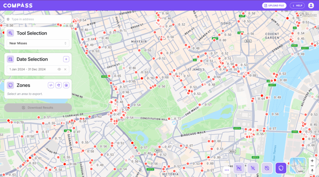
As part of the RILM project in 2025, Compass IoT will pilot its Road Intelligence platform and develop a bespoke dashboard for TfL. The project is leveraging the platform to integrate real-time high-frequency floating vehicle datasets from Compass IoT alongside TfL’s bus and crash data. This fusion of data sources provides a holistic, continuously updated picture of London’s transport ecosystem to further inform transport planning and targeted interventions for better mobility. Importantly, Compass IoT’s approach requires no new roadside hardware – all insights are derived from anonymised, connected vehicle telemetry – meaning rapid and cost-effective deployment across entire regions.
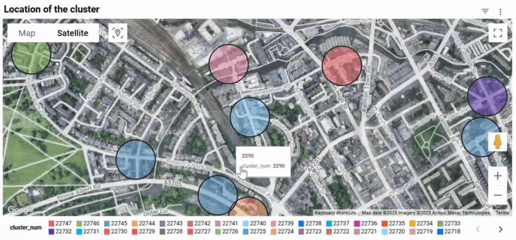
Using TfL collision data from 2023-2024 and Compass IoT near-miss data from 2023-2025, 22,748 collision clusters and 14,170 near-miss clusters were identified across the whole network. These collision and near-miss insights help TfL identify and shortlist hot-spots including high-risk junctions and implement targeted safety measures such as improved signal timing, recalibrated speed limits, redesigned junctions or improved signage, enhancing road safety for vulnerable users such as cyclists and pedestrians. High-frequency bus data is also being used to understand delays and travel times across the whole journey for select bus routes. Data on average wait time, travel time through intersections and queue length at intersections across peak and off-peak times provides insights into where to enhance bus service reliability and optimise signal timing to reduce average journey times across key intersections in the city.
Compass IoT’s Road Intelligence platform provides TfL with actionable insights on near-miss events, congestion trends, and traffic energy levels. These insights empower data-driven decisions aligned with the city’s vision of reducing congestion, improving air quality, and saving lives. Importantly, RILM’s integration of connected vehicle data represents a foundational step toward a data-centric, predictive transport management model for London’s future.
The road ahead
As vehicle connectivity becomes universal, the role of floating car data in shaping policy, infrastructure, and urban design will only grow. The ability to see, model, and manage road networks in real-time represents a fundamental leap forward in how cities understand mobility.
Compass IoT’s involvement in the RILM project illustrates how connected vehicle analytics can transform city mobility at scale. Projects like RILM demonstrate how collaboration between technology providers such as Compass IoT and public agencies can accelerate this transition, turning streams of vehicle data into powerful intelligence for safer, cleaner, and more efficient cities.
[1] https://www.juniperresearch.com/press/connected-vehicles-to-surpass-367-million-globally/
[2] https://copenhageneconomics.com/wp-content/uploads/2024/12/Copenaghen-Economics_A-study-on-the-market-for-in-vehicle-data_20241204_FINAL.pdf
[3] https://content.tfl.gov.uk/casualties-in-greater-london-2024.pdf#:~:text=There%20were%2020%2C989%20reported%20collisions%20in%20London,injured%20and%2020%2C312%20people%20being%20slightly%20injured.